
Storm ‘Nadine’ is gaining steam in the Atlantic – and its odds of becoming a tropical storm have tripled.
The National Hurricane Center (NHC) released its updated forecast Tuesday, showing a 30 percent chance by Thursday.
The previous report showed just a 10 percent chance that the storm would reach tropical storm proportions within 48 hours.
The upgrade comes amid intensifying wind speeds.
Meteorologists are closely monitoring potential Nadine that could barrel over Florida or take another path toward Mexico and Central America.

A tropical depression is making its way toward Florida and could be upgraded to a tropical storm in the coming days
‘This system is forecast to move generally westward, and environmental conditions could become more conducive for gradual development by the middle to latter part of this week,’ the NHC shared in the 8am ET update.
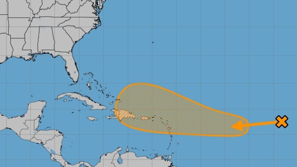
The storm, formally known as Invest 94L, was previously categorized ‘as a disturbance,’ but was upgraded to a tropical depression Monday after its surface winds reach 38 miles per hour that created cyclones on the Atlantic.
When it approaches warmer waters, a depression brings devastating rain and thunderstorms that cause severe floods and can develop into a hurricane if it reaches 74-mile-per-hour winds.
It’s unclear if the tropical storm will definitively develop or when, but the NHC said the storm has a 60 percent chance of growing into a tropical storm within the next seven days.
The tropical depression is currently located several hundred miles west of the Cabo Verde Islands but could gradually develop into a hurricane as it reaches the warmer waters near Florida.
It is expected to track northwest, passing Antigua’s northern tip and head toward the Dominican Republic and southeastern coast of Cuba.
‘There still is a scenario where that feature could find a way farther to the north and enter the southeastern Gulf of Mexico, but the chances of that seem to be diminishing,’ AccuWeather meteorologist Alex DaSilva reported.
However, there is now a second area of concern as an area of low pressure is developing over the southwestern Caribbean Sea.
There are ‘two main areas that are most likely to spur tropical development in the next few days to a week or so, and one or both features could still find a way to impact Florida,’ AccuWeather meteorologists told USA Today.
The second storm, which will be named Oscar, ‘has been showing some signs of life off and on in recent days but could be entering a much more favorable area for tropical development this week as it nears the Leeward Islands in the northeastern Caribbean,’ DaSilva said in the AccuWeather report.

If the tropical depression in the Atlantic makes landfall it would occur in the next nine days
DaSilva told DailyMail.com that it’s unlikely the storm will reach hurricane status.
As the storm passes over the Virgin Islands, the mountains could disrupt its growth.
He added that ‘there is a low chance of direct impact to the US because there’s a wind shear that might protect us.’
A wind shear consists of strong upper-level winds that can remove the heat and moisture from the eye of a hurricane and distort its shape, effectively ripping it apart.
If the storm were to develop into something bigger, DaSilva said it likely won’t occur until October 17 through 18 and meteorologists won’t know which path the storm will take until then.
‘I don’t think would it would hit us at all,’ he said, adding that ‘it will either just be pushed out to sea or nothing left by the time it gets to the US.’
However, the storm is still very far out and if it does impact the States, it wouldn’t be for another nine days, ‘so things can still change,’ DaSilva said.
The storm’s strength depends on how long it spends over water which could allow it to grow and develop into a hurricane.
‘One possibility would take the system westward into Central America and southern Mexico, and the other is, unfortunately, toward Florida,’ DaSilva said in an AccuWeather report.
If the tropical depression moves toward Central America, it won’t have as much time to strengthen, but if it’s path shifts northern toward the Gulf of Mexico, it could provide the climate needed to grow.
‘Not only are waters very warm in this area—well into the 80s Fahrenheit down deep- the ocean heat content in the western Caribbean is at record high levels for any time of the year,’ DaSilva said in the report.

The tropical storm could head for Florida or Mexico and Central America over the next week
The impending storm comes as Florida is working to recover from Hurricane Milton which hit Tampa and traveled across the state last week and triggered deadly tornadoes.
At least 17 people were killed in Florida and while the state is still assessing the financial toll, the damages are estimated to be in the billions.
Milton also came after Hurricane Helene which struck the southeast two weeks prior, leaving states up and down the coast under water.
Helene cost between $30.5 billion and $47.5 billion in total damages across 16 states, according to CoreLogic, and has so far claimed the lives of more than 230 people, with countless others still reported missing.
This year has already seen above average hurricanes for mid-October, with four major hurricanes including Beryl, Helene, Kirk and Milton hitting the US.
In May, National Oceanic and Atmospheric Administration (NOAA) reported that the US would have an above-average hurricane season and predicted between four and seven Category 3 or higher hurricanes would strike.
The prediction so far has proven true, with mid-October seeing above historical averages.
The hurricane season extends from June 1 through November 30.
DailyMail.com has reached out to the National Hurricane Center for comment.